Monday 9 October 2017

Waterberg Wilderness Reserve - October 2017

Camping at the Waterberg Wilderness Reserve - October 2017


We (John, Anne Sue and myself) decided to try a camping weekend at a park where there was to be no electric power. John wanted to see if his solar panel worked ok and I wanted to check if my battery system would work my fridge for the entire weekend. My freezer in the camping trailer works on 12v, 220 and gas. So that ran off gas the weekend.

For this, we decided to book at Waterberg Wilderness Reserve. The website looked good, so we made the booking a few months ago.

Waterberg Wilderness describe the park as :
The Waterberg mountain range is situated in the Limpopo province of South Africa and is one of the more pristine, scenic and wildlife rich areas in South Africa. Positioned on the Eastern side of the Waterberg range the Waterberg Wilderness reserve is only 5 hours from Johannesburg and conveniently positioned half way to Botswana. Due to the rugged nature of the reserve which is typical of the Waterberg, a 4×4 vehicle or vehicle with good ground clearance is recommended to access the property. In the wet season a 4×4 vehicle is often essential.
Certain areas of the Waterberg Wilderness Reserve offer spectacular views over the surrounding hills and valleys and exploring the impressive gorges with natural streams and pools is certainly a highlight. The reserve is ideal for the more active with some beautiful walks and potential mountain bike trails.
The game lodge offers accommodation in the Waterberg Wilderness camp but is exclusive and can only accommodate a maximum of 12 guests in the 4 safari tents with an additional 2 campsites available. All accommodation is self catering with comfortable and complete facilities.
All game drives are in your own self drive 4×4 vehicles.

In another section of the website, it explains that the park is only 2.5 hours from Johannesburg. I checked on Google maps and my Garmin, and yes, it was 2.5 hours. So we were sorted.

Sue and I left Friday morning and made our way, slowly as there was no rush, to the park. We arrived at about 12h30 and checked in. The dirt road up to the gate is ok, but it has some bad sections,. You definitely will not get in with an ordinary vehicle.  
We were directed to our site and soon settled in to a comfortable weekend.


It was so nice to have peace and quiet. The sites have private ablutions and the water is heated via a gas geyser. So no problems there.
The camp staff are extremely friendly, pleasant and anything that we asked was taken care of immediately and without any fuss.
Another very nice thing about the reserve is that the sites are a long way apart and private. So even if there were other campers, we would not have seen them from our campsite. The reserve also has safari tents where each tent has a built in bath and shower. A fully equipped kitchen as well as a braai area. Oh, there is also an outside shower, private and with a view of the bush. Looked lovely.

We were camping in Bee Eater private campsite. It was large enough for two (or more) camping trailers and we were not even on top of each other, fantastic !


Each afternoon braai wood was delivered by an old Massey Furguson tractor.

We enjoyed two very pleasant braai's, one Friday and the other Saturday evening.

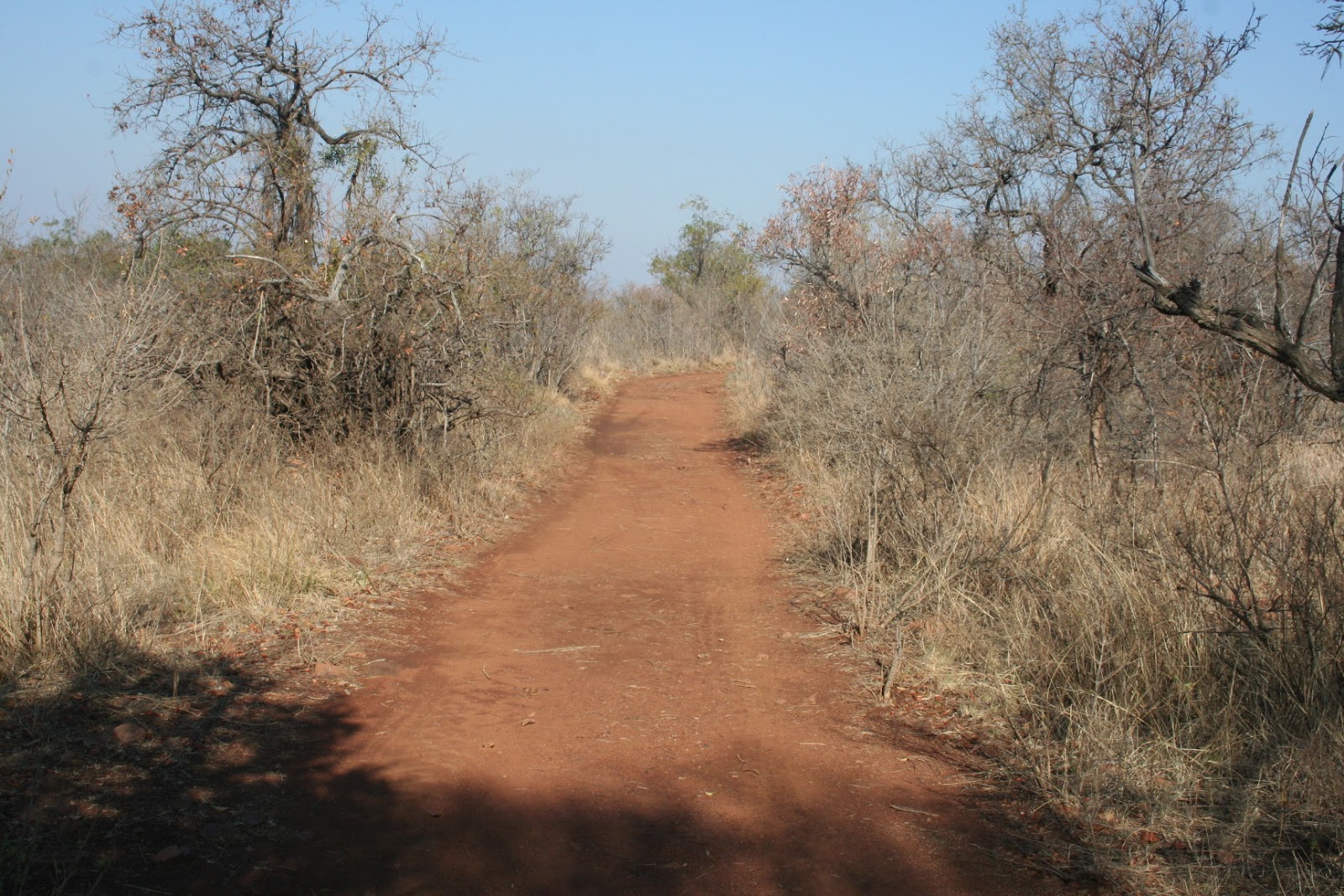
On the Saturday we went for a drive around on the 4x4 tracks, We were provided with a very comprehensive map and each intersection is marked by a rock with a number pained onto it. The roads were actually in a good condition and not bad at all.


We did see some of the game that is on the farm. Giraffe, Zebra, Kudu, Nyala and Wildebeest. There are others, but we did not see them. Also did see a few bird species as well.

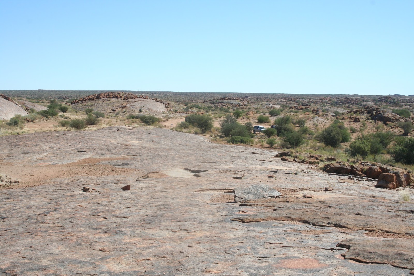
On the Sunday we went for a drive to a view point.

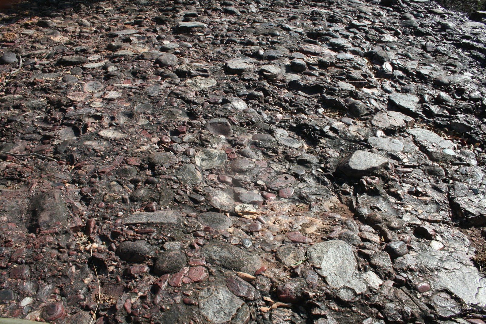
It did not look like much from the parking spot, or from the path leading from the signpost.
But, when we got there, the cliff was actually made up of conglomerate. According to the web, conglomerate rock is :
Conglomerate ( /kəŋˈɡlɒmərɪt/) is a coarse-grained clastic sedimentary rock that is composed of a substantial fraction of rounded to subangular gravel-size clasts, e.g., granulespebblescobbles, and boulders, larger than 2 mm (0.079 in) in diameter. Conglomerates form by the consolidation and lithification of gravel. Conglomerates typically contain finer grained sediment, e.g., either sandsiltclay or combination of them, called matrix by geologists, filling their interstices and are often cemented by calcium carbonateiron oxidesilica, or hardened clay.
The size and composition of the gravel-size fraction of a conglomerate may or may not vary in composition, sorting, and size. In some conglomerates, the gravel-size class consist almost entirely of what were clay clasts at the time of deposition. Conglomerates can be found in sedimentary rock sequences of all ages but probably make up less than 1 percent by weight of all sedimentary rocks. In terms of origin and depositional mechanisms, they are closely related to sandstones and exhibit many of the same types of sedimentary structures, e.g., tabular and trough cross-bedding and graded bedding

It was actually quiet spectacular and the view down into the valley was also great. We were pleased that we had made the effort.


We also took the opportunity for a few "people" photographs.


Well, that was Sunday morning and we returned to the campsite for a very nice breakfast of bacon, sausage, eggs, brinjal and mushrooms as well as toast. Was good.
Thereafter we packed up slowly and made our way back home. Unfortunately you have to travel along the N1 and the drivers were driving like fools. passing in the left emergency lane. One fellow was just driving, fast, in the emergency lane for km's on the N1. They also try to push other vehicles off the road. But, luckily, we all made it home safely.

Was another lovely weekend camping !!

Monday 21 August 2017

RADAR - GPS Tracking Made Easy

RADAR - GPS Tracking Made Easy


Radar brings you the simplest GPS tracking mechanism yet. Keep tab on your assets in your web browser or on your Android device with our new app.
gps tracking get radar getradar icasa Durban South Africa Cape Town Johannesburg geofencing geo-fencing


Track Your Vehicle

With updates every minute, you can have peace of mind as you know where your vehicle is at all times.

gps tracking get radar getradar icasa Durban South Africa Cape Town Johannesburg geofencing geo-fencing

Vehicle History

The ability to look up a detailed history of your vehicle's travel paths and speed.


gps tracking get radar getradar icasa Durban South Africa Cape Town Johannesburg geofencing geo-fencing

SMS Alerts

The panic button functionality allows you to alert designated people to any emergency you may encounter.

gps tracking get radar getradar icasa Durban South Africa Cape Town Johannesburg geofencing geo-fencing

Geofencing

Set geographical boundaries and be alerted when a vehicle leaves the perimeter.

gps GPS tracking get radar getradar icasa ICASA

gps GPS tracking get radar getradar icasa ICASA

Specifications


Dimensions:72 x 50 x 25 mm
Weight:50 grams
Enclosure:ABS Thermoplastic
Operating Temperature:-20 to +70 degrees C
Humidity:< 96% (Non-condensing)
Power Requirements:5, 12 - 24 V DC
Battery:1100 mAh 3.7 V Li-ion Polymer

Possible Uses for the Radar GPS Tracking Device

TRACKING FOR :

1)    4x4 Overland Safari
2)    Africa continental travels
3)    Vehicle rental companies
4)    Safari vehicles
5)    Trailer hire companies
6)    Off-road caravan rentals
7)    Caravan rentals
8)    Construction company vehicles
9)    Mining vehicles
10)  Boats
11)  Yachts
12)  Water craft
13)  Recovery vehicles
14) Taxi vehicles
15) Family vehicles
16) Assets tracking

In fact, Radar can be utilised for any and all vehicle/asset tracking and provides peace of mind and easily viewable route and location

Get RADAR and ensure that when your vehicle breaks down in a remote area you know that someone will be able to locate you.
Also used for asset tracking and monitoring.

ASSET TRACKING ON THE INTERNET - COMPUTER / SMART PHONE
SOLAR POWERED / VEHICLE CHARGER / MAINS CHARGER
SMALL SIZE - 70 x 50 x 25 mm - WEIGHT 50 grams
LOCATION – CURRENT POSITION AND SPEED AVAILABLE 24 / 7
Position / date / time / speed / battery level
Geo-fencing alerts via SMS
Low battery, charger disconnected alerts via SMS
Panic button SOS message
ROUTE AND DISTANCE TRAVELLED
HISTORICAL DATA STORED ON WEBSITE


Contact

Dave by sending/posting a comment to this blog. Thank you.


WWW.getradar.co.za 

Thursday 3 August 2017

Soutpansberg - Makhado

Soutpansberg - Makhado - July 2017


So, it was winter and a little cool in Johannesburg. Elizabeth was down from Zambia for a knee operation, and during her recover period I though that it would be good to go camping somewhere where it would be a little warmer. 

I looked around and was looking for a place that would be quiet and peaceful without the noisy crowds. I was also interested in visiting the Soutpansberg, as we had not been to that part of the country previously. I searched the web and found a place which sounded good. It was near Makhado and at the start of the Soutpansberg mountains.

So I booked at Zvakanaka, which is a small camping/caravan park on a farm, just past Makhado.
We set off early on a Wednesday morning, from Johannesburg. We were in no rush and stopped off at one of the Sasol fuel stations on the way (near Mokopane) for a bite of lunch. The trip up went well and the Trailblazer and Jurgens Avion L had no problems at all.


The road from Johannesburg is dual carriageway most of the way. However, after Makhado it turns into a single carriageway road, with a few overtaking lanes every 10 to 15 Km's or so. 

The South African road users have absolutely no idea what any of the road signs or markings are for. They pass on solid white lines, blind rises and corners where they cannot see anything. They seem to have a belief that nothing will ever happen to them and on numerous locations they simply pushed oncoming traffic into the verge, else they would have caused an accident. I think that the SA roads department are wasting money and should do away with all road signs and markings - hardly anyone obeys then anyway. And speed limits mean absolutely nothing. Even had a Bakers truck try and push us off the road. I believe that South Africa has a obscenely high road death toll because the road users simply disobey the rules of the road. Its really nothing to do with speed, which of cause can also be a factor when a large number of vehicles are roadworthy.
But, if you just drive carefully, you will still have a great holiday !!

Anyway, we arrived safely at our camping destination and used a code (which we were given) to open the gate. The farm is very rustic and the campsites are far apart and you don't even see the other campers. We set up camp, in the shadow of the Soutpansberg mountains.


Each of the campsites has a boma, and that boma has a table as well as a gas stove and oven. It makes camping really nice and this was a really good idea. The boma also has a cement floor and its big enough for 4 or 5 chairs as well.
We had electricity and I think that 3 of the 4 sites have that. So I was able to plug the caravan in and use our fridge and freezer.


In addition, each site also has a nice brick built braai, as well as a separate fire pit. Some wood is provided for each evening, and more is available for purchase.


We had a very nice fire each evening. Some of the evenings were cold and the fire really made a nice difference.


Zvakanana, on their website, advises :

Zvakanaka farm is 74 hectares in area and the three main vegetation types are grassland, wetland and semi-deciduous scrub-forest. There are numerous trails cut on the farm and, depending on how much energy you want to exert, you can either take gentle strolls or more serious walks to the very top of the mountain where there are stunning views in all directions. The bird-life on the farm is plentiful and varied – the cliffs, grasslands, forest and the wetland ensure a wide range of species. Many of our guests express their delight in the chorus of bird calls during their time on the farm – particularly at dusk and dawn. Zvakanaka means “Everything’s OK!” or, if you like, “Lekker”, andthat’s the feel that we’d like to impart to our guests.Zvakanaka farm is perfectly situated, both for people wanting an easily accessible destination for a tranquil escape, or for those who need a base from which to explore the richly diverse surroundings. If you want to visit the fascinating and beautiful Mapungubwe, say, but would rather overnight on the cool slopes of the Soutpansberg, then you can easily take a day drive – the trip to the park takes approximately two hours via Musina. 

Most of the days that we were at Zvakanaka were cool and misty. The sun did break through mid morning, but the breez also made it cool when you were in it.


The ablution facilities at the campsite are very good. They are a little different, in that there are four toilets and two showers all in a row. They are shared by male and female, which is not a problem. The water was always boiling hot and the showers and toilets were always clean. Toilet paper is provided.


The facilities also have a washing machine as well as a large fridge and freezer, should you need these.

The farm has a number of walking trails, some of which take you to the top of the mountains. The trails are all clearly marked. We walked a few, but keeping near the bottom of the mountain.


All in all, we had a great relaxing quiet time. 

The travel takes you past the Tropic of Capricorn and on the way up "North" we passed a sign to a monument. So on the way back hole we decided to stop off the the Tropic Of Capricorn monument and see what it was all about. 
Well, whoever is responsible for this monument should be ashamed of themselves. The site was a disaster. the sign is full of bullet holes and some of the lettering on the monument has been stolen. There is also a cultural stall/center but this is derelict and deserted.  


Anyway, I suppose that is Africa !!

We had a safe trip back hone. We stopped off at The Ranch for lunch and found the Maxis there to be good (others have been diabolical).

Until next time.


Monday 22 May 2017

Augrabies National Park and kgalagadi Transfrontier Park

Augrabies National Park and kgalagadi Transfrontier Park


Its April and time for a break !
So, this year we are heading into the Northern Cape Priovince http://experiencenortherncape.com/visitor/.

We, myself and my wife as well as my brother and his wife were travelling from Johannesburg and Pretoria. We had decided to meet at the junction of the N14 and R26 (opposite Cradelstone Mall).

Its quiet a long way from Johannesburg and Pretoria, through to Augrabies. So we decided to take a break at a resort just outside Kuruman. Because of this, we also decided to leave 2 days earlier, on the Friday, and spend two nights at the resort.

However, we left Gauteng early because we planned to stop off at Barberspan. According to the web site :  "The Barberspan Bird Sanctuary is a huge 2000 ha body of water located between Delareyville and Sannieshof. The Reserve is a pioneer in ornithological research. Bird Life South Africa has declared it an important national birding site.
Given then that it is also a RAMSAR Convention-accredited wetland of international importance for migratory birds and waterfowl, it is well worth a visit."
Well we battled to find the entrance gate and arrived at a very, very run down hotel on the dam shores. They directed us back, about 1km. We eventually found the gate.

The Barberspan Bird Sanctuary is in a sorry state. There were loads of birds, all nesting in a few trees. The trees were full of dead and dying birds, some hanging from branches. Beneath the trees there were also dead birds. We were not impressed and Sue, in fact, sent a mail to Barberspan. A reply was received, but we definitely wont be rushing back there.
The roads in the reserve were good. There were also some campers along the shores of the dam.


We stopped off at a Pad Stal, but due to it being Good Friday, it was closed (so were all the others we tried to stop at).


However, we finally arrived at our overnight destination. The resort that we had selected was Red Sands Country Lodge. http://www.redsands.co.za/
Its 15 Km west (towards Upington) of Kuruman and on the N14, which is the main road from Johannesburg to Kuruman. We arrived at the entrance and you have to buzz to reception who open for you. Its about a 3km drive on red sand roads to reception.
The lodge is really very nice and we had a two bed roomed chalet for our stay there.

The lodge is located in a game farm and there are plenty of roads that one can drive around. There are also some 4x4 roads and we tried most of them out over the 2 days. We also found that there was a bird hide near a small dam. Here we spent a few hours viewing some of the bird species that can be seen in the area. The resort also has Fallow Deer and we did see a few of these as well.

Entrance gate to Red Sands


The bird hide


View from the top of one of the 4x4 drives. This is made to look like a windmill, but its in fact a communications tower. The views were stunning.


The chalet


Some of the birds spotted


After a lovely relaxing two night at Red Sands, we departed for Augrabies Falls National Park. The trip took us through Upington, where we stopped off for a few supplies.


 Augrabies National Park https://www.sanparks.org/parks/augrabies/

We arrived at Augrabies early afternoon and the reception was good efficient and friendly. We were soon all set up and ready for a walk to the falls.


We had tried to search the web to see the volume of water flowing over the falls. The Orange river was not as full as we had expected. Nevertheless the falls were still an amazing site. There are now wooden walkways all along the side and viewing decks at the main falls as well. It was a nice relaxing walk.
Some facts, perhaps of interest :
Augrabies_Falls

Augrabies Falls

From Wikipedia, the free encyclopedia
Augrabies Falls
Augrabies Falls, March 2008.jpg
Augrabies Falls
LocationNorthern CapeSouth Africa
Coordinates28°35′29″S 20°20′27″ECoordinates28°35′29″S 20°20′27″E
TypeCascade
Total height56 metres (183 ft)
Average width24 metres (80 ft)
WatercourseOrange River
Average
flow rate
313 cubic metres (11,050 cu ft)
The Augrabies Falls /ɔːˈxrɑːbz/ is a waterfall on the Orange RiverSouth Africa, within the Augrabies Falls National Park. The falls are around 183 feet (56 m) in height.[1] Some sources cite an approximate height of 480 feet; this is actually the height from the base of the canyon to the top of the walls, not that of the falls themselves.[1] The original Khoikhoi residents named the waterfall "Ankoerebis" — "place of big noises" — from which the Trek Boers, who settled here later on, derived the name, "Augrabies".[2]
The falls have recorded 7,800 cubic metres (280,000 cu ft) of water every second in floods in 1988 (and 6,800 cubic metres (240,000 cu ft) in the floods of 2006). This is over three times the average high season flow rate of Niagara Falls of 2,400 cubic metres (85,000 cu ft) per second, more than four times Niagara's annual average, and greater than Niagara's all-time record of 6,800 cubic metres (240,000 cu ft) per second.
The gorge at the Augrabies Falls is 240 metres (800 ft) deep and 18 kilometres (10 mi) long, and is an impressive example of granite erosion.


We were camping at Augrabies for a few nights, so we also decided to do the drive trail that the park has on offer. It was amazing to see the contrast. The barren and dry rock landscape, and then we were also driving through reeds and running riverbeds. That was quiet amazing !


The drives have numerous view points to stop off at and you can get some stunning views of the gorge
.


We also climbed up Moon Rock.

Augrabies Falls National Park

From Wikipedia, the free encyclopedia
A prominent landmark in the park is Moon Rock, a large exfoliation dome measuring around 700 metres (2,300 ft) by 100 metres (330 ft) and 30 metres (98 ft) high.[1][8]


We packed up from Augrabies and were heading to Kgalagadi. This entailed going back to Upington and then heading up the R360 to the park. This is now a very nice tarred road.

On the drive up from Upington we stopped off at the small town of Askam. The main reason was because we have been advised that the petrol situation at Twee Rivieren was not good and that we should fill up at Askam. We did. In addition, we also stopped off at the cafe and had a good coffee and cake.

Kgalagadi Transfrontier Park https://www.sanparks.org/parks/kgalagadi/

We arrived at the park reception and were soon through with the formalities and ready to select our campsites. There are not many trees, I suppose that can be expected. But we did find a little shade and each site has a power point and braai. Ablutions are communal.
These were ok, except for the fact that there was no hot water. I did complain about that fact, but was informed its because children play around the geysers and break them ! Quiet a lame excuse from SanParks, I thought.


Our 4 days were all spent at Twee Rivieren camp. We had originally booked for 5 nights, but Sue and I had to come back earlier as our daughter was coming out from Scotland for a visit.

The roads within the park are all dirt roads. We did see a grader, but the fellow obviously drives around with the blade up. The roads are so badly corrugated that even with the tyres deflated to 1.1 bar, the experience is still teeth shattering!!

We did see quiet a few animals. Two sightings were amazing. These were a snake in a tree as well as some owls in a tree.

The snake :


The Owls


There was also an incident of a bird of prey catching and eating a snake


The lion sighting


Ostrich with young chicks


Many other sightings


We packed up, leaving John and Anne there, so that we could had home to meet Jenny (arriving from Scotland). John and Anne were also going onto Witsand Kalahari for two nights.

Our trip home was great. We stopped off at Red Sands Kalahari again. Except this time we camped for the one night. The Fallow Deer kept us entertained most of the evening with their rutting and snorting.
The camp site is good, and we had a private ablution which was excellent.

A fantastic trip !

Until next time.


SINJEMBELA - ZAMBIA

ROAD TRIP - SOUTH AFRICA, NAMIBIA, ZAMBIA AND BOTSWANA Our missionary daughter Elizabeth got married to Mubita on 23 November 2019. Then...